
Top 10 Places On Earth With Unsolved Mysteries

The universe is an amazing place. It has lots of mysterious things since its beginning. Actually, we haven’t a clear idea about the beginning of the universe but lots of scientists accept the Big Bang theory. The Big Bang was the moment 13.8 billion years ago when the universe began as a tiny, dense, fireball that exploded. According to that theory, there are neither planets nor living things before the big bang. After that big bang, planets formed and then gradually came into living things.
13.8 billion years
later, one thing has existed ever since. It is the mystery of the universe. We couldn’t
solve those things until now but people are sorry for that. Because the universe is
a huge and amazing place that we can’t understand. It hasn’t measurable height,
width, or depth.
Earth is a very small part compares with the universe but we don’t know a lot of things about our world. Some places people haven’t even seen yet but some places are very famous. People aren’t sorry for that. Now you can study 10 places among them. You may have seen some places but the mystery of those places is still unsolved. Do you know those mysteries?
Bermuda Triangle

Bermuda Triangle is a very famous mysterious place. Some call it the Devil's Triangle. It covers around 500 000 square miles of the Atlantic Ocean between Miami in Florida, San Juan in Puerto Rico, and the island of Bermuda where dozens of ships and airplanes have disappeared. There are lots of mysteries about the Devil's Triangle. It has a long history.
- The Bermuda triangle legend begins in 1492, on the night of October 11. Christopher Columbus reportedly saw an unknown light falling into the sea during his first voyage, shortly before landing in Guanahani.
- William Shakespeare’s play “The Tempest,” which some scholars claim was based on a real-life Bermuda shipwreck, may have enhanced the area’s aura of mystery
- In March 1918, the USS Cyclops, a 542-foot-long Navy cargo ship with over 300 men and 10,000 tons of manganese ore onboard, sank somewhere between Barbados and the Chesapeake Bay. The Cyclops never sent out an SOS distress call despite being equipped to do so, and an extensive search found no wreckage.
- In 1941 two of the Cyclops’ sister ships similarly vanished without a trace along nearly the same route.
- Flight 19 was a training flight of five TBM Avenger torpedo bombers that disappeared on December 5, 1945, while over the Atlantic. The squadron's flight plan was scheduled to take them due east from Fort Lauderdale but the flight never returned to base.
- G-AHNP Star Tiger disappeared on January 30, 1948, on a flight from the Azores to Bermuda
- G-AGRE Star Ariel disappeared on January 17, 1949, on a flight from Bermuda to Kingston, Jamaica.
- On August 28, 1963, a pair of US Air Force KC-135 Stratotanker aircraft collided and crashed into the Atlantic 300 miles west of Bermuda

The Nazca Lines in Peru

The Nazca Lines is another very famous mysterious place. The Nazca Lines are a group of very large geoglyphs made in the soil of the Nazca Desert in southern Peru. They were created between 500 BCE and 500 CE by people. Peru dessert depicts various shapes, including 70 identifiable animals and plants. These images can only be seen properly from above. The lines are massive, some measuring over a kilometer. Scientists studied for over 80 years then they were designated a UNESCO World Heritage Site in 1994.
- There are more than 800 straight lines on the coastal plain, some of which are 30 miles (48 km) long.
- There are over 300 geometric designs, which include basic shapes such as triangles, rectangles, and trapezoids, as well as spirals, arrows, zig-zags, and wavy lines.
- It is best known for the representations of about 70 animals and plants, some of which measure up to 1,200 feet (370 meters) long.
- spider, hummingbird, cactus plant, monkey, whale, llama, duck, flower, tree, lizard, and dog are some of the animals.


The desert floor is covered in a layer of iron oxide-coated pebbles of a deep rust color. The ancient peoples created their designs by removing the top 12 to 15 inches of rock, revealing the lighter-colored sand below. More recent research suggested that the Nazca Lines’ purpose was related to water. The geoglyphs weren’t used as an irrigation system or a guide to find water but rather as part of a ritual to the gods to bring much-needed rain. All things are suggestions but those geoglyphs are still a mystery to researchers.

Hidden people and Elves in Iceland


So Many Icelanders Still Believe in Invisible Elves. In one 1998 survey, 54.4 percent of Icelanders said they believed in the existence of elves. In addition to that, according to an academic paper published in 2000 titled “The Elves’ Point of View" by Valdimar Hafstein, who now is a folkloristics professor at the University of Iceland. “If this was just one crazy lady talking about invisible friends, it's really easy to laugh about that,” Jónsdóttir said. “But to have people through hundreds of years talking about the same things, it’s beyond one or two crazy ladies. It is part of the nation.” I agree 100% with him because it became a part of their culture.

A 2006 survey found that "54% of respondents did not distinguish between elves and hidden people, 20% did and 26% said they were not sure. That is the situation now in Iceland but I have an unclear point. If it is the only folk tale, Why 20% of people believe that until then. Peoples are very educated and smart now so they can easily tell if it is a folk tale or not.

The Eternal Flame in New York

It isn't enough to explain that situation. Typically, shale must be hot (around 100 °C) for its carbon structures to break down and form smaller natural gas molecules. However, the shale from which Eternal Flame Falls draws its gas is much cooler, in addition to being younger and shallower than typical gas-bearing shale. This may indicate that additional, as yet undemonstrated, processes can contribute to the creation of natural gas in shale; one possibility is that a catalyst capable of breaking down shale in cooler conditions is present.
The Crooked Forest of Poland

You can see crooked people around the world but you can't see the crooked forests except in Poland. If you need to see the crooked forest, you should go to the town of Gryfino, West Pomerania, Poland.
This groovy grove of trees is a weird wonderland of some 400 pines that took a definite detour in the ol’ “growing straight as a tree” routine. This grove of pines was planted in the village of Nowe Czarnowo around the 1930s and whatever caused them to waver in their sky-striving happened when they were seven to 10 years old. Each pine tree bends sharply to the north, just above ground level, then curves back upright after a sideways excursion of three to nine feet (1–3 m). The curved pines are enclosed by a surrounding forest of straight pine trees.
There are many theories on the mystery.
- Some hypothesize that a unique gravitational pull in this particular area caused the trees to grow curved northwards.
- Others guess that the heavy snowfall in the area weighed down the trees as they were sprouting, causing them to grow crookedly at the base.
- Some suspect that the trees were grown for the rims of wooden cartwheels as the grain direction would have produced very tough wheels.
- The most widespread and most likely explanation is that local farmers planted and manipulated the trees when they planted them in 1930.
Uluru in Australia

The huge red rock of Uluru is one of Australia’s most iconic attractions. Uluru is known as Ayers Rock. Uluru is a large sandstone rock formation in the southern part of the Northern Territory in Australia. It lies 335 km southwest of the nearest large town, Alice Springs. It rises dramatically from the Central Australian desert. Its origins date back to around 600 million years, just as old as the Australian continent itself. Historically, 46 species of native mammals are known to have been living near Uluru. Furthermore, Uluru is a UNESCO World Heritage since 1987.

Uluru has been a popular destination for tourists since the late 1930s. Uluru was first mapped by Europeans in 1872 during the expeditionary period made possible by the construction of the Australian Overland Telegraph Line. In separate expeditions, Ernest Giles and William Gosse were the first European explorers to this area. While exploring the area in 1872, Gosse observed Uluru and named it Ayers' Rock, in honor of the Chief Secretary of South Australia, Sir Henry Ayers.
This rock has an unsolved mystery thing. That mystery is how Uluru changes colour depending on the position of the sun. It is a huge red stone that turns into a magical vibrant pink as the sun rises, shades of amber during noon, and yellow ochre as the sunsets.
In addition to that thing the old traditions of the Australian Aborigines believe it’s one of the last remaining homes of the creator beings who forged the earth. Meanwhile, other folks come here to energise themselves at the fluvial channels that run underneath the rock. What is the meaning of those things?
Easter Island in Polynesia

Easter Island is a mysterious and famous island and special territory of Chile in the southeastern Pacific Ocean, at the southeasternmost point of the Polynesian Triangle in Oceania. Estimated dates of early settlement on Easter Island are c. 300 to 1200 but the name "Easter Island" was given by the island's first recorded European visitor, the Dutch explorer Jacob Roggeveen, who encountered it on Easter Sunday (5 April) in 1722, The island is most famous for its nearly 1,000 extant monumental statues, called moai, which were created by the early Rapa Nui people. That island is a UNESCO World Heritage since 1995, with much of the island protected within Rapa Nui National Park.

Lake Natron in Tanzania

Lake Natron is an amazing and dangerous creature of nature. It situated in northern Tanzania on the border with Kenya, lying in the East African Rift System, 70 miles (113 km) northwest of Arusha. The lake is fed principally by the Southern Ewaso Ng'iro River, which rises in central Kenya, and by mineral-rich hot springs. It has a 3-meter depth, a maximum of 57 kilometers length, and 22 kilometers width.
This lake is more special than other lakes because It can do something amazing that no other lake can. This lake has mummification mastery. The alkalinity of the lake can reach a pH of greater than 12. so it can burn the skin and eyes of animals that aren't adapted to it. The water's alkalinity comes from the sodium carbonate and other minerals that flow into the lake from the surrounding hills. And deposits of sodium carbonate which was once used in Egyptian mummification and it also acts as a fantastic type of preservative for those animals unlucky enough to die in the waters of Lake Natron.
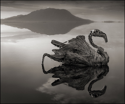
On the other hand, Lake Natron's alkaline waters support a thriving ecosystem of salt marshes, freshwater wetlands, flamingos and other wetland birds, tilapia, and the algae on which large flocks of flamingos feed.

Nick Brandt who is the writer of "Across the Ravaged Land" said "I unexpectedly found the creatures — all manner of birds and bats — washed up along the shoreline of Lake Natron," Brandt wrote in his book. "No one knows for certain exactly how they die, but … the water has an extremely high soda and salt content, so high that it would strip the ink off my Kodak film boxes within a few seconds."
This lake supports some beings but It kills some living things. What is the reason for it? That is the mystery.

Devil's Kettle Falls

Devil's Kettle is another famous and unsolved mystery place in the world. It is situated in Judge C. R. Magney State Park in the U.S. state of Minnesota, on the North Shore of Lake Superior. The park is best known for the Devil's Kettle, an unusual waterfall and rock formation in which half of the Brule River disappears into a pothole.
The Devil's Kettle waterfall is located on the Brule River 2.4 km from its mouth. The river splits in two to flow around a mass of rhyolite rock. The eastern flow goes over a two-step 15 m waterfall and continues downstream. The western flow surges into a pothole, falling at least 3.0 m from where it was popularly understood to "disappear underground."
For years, people have tried to figure out where that water goes. Logs and Ping-Pong balls tossed into the churning cauldron seemed to simply vanish, fueling speculation that the lost branch of the river might flow for miles underground, carrying bobbing debris down to the distant shores of Lake Superior or off to some underground cavern.
In February 2017, the Minnesota Department of Natural Resources said that water that disappears into the rock at Devil's Kettle resurges in the stream below the waterfall. Hydrologists compared the amount of water flowing above the waterfall with the amount flowing below it to see if some water was lost somewhere between the two locations.
Green and a team of DNR hydrologists used stream gauging equipment to measure the volume of water flowing above the falls and below. hydrologists measured water flow above Devil's Kettle at 123 cubic feet per second, while several hundred feet below the waterfall, the water was flowing at 121 cubic feet per second.
In the world of stream gauging, Green explained, those readings are nearly identical. The river didn’t go anywhere.So if the river didn’t stray far, why didn’t the Ping-Pong balls and other debris resurface downriver? That is the question.

Sigiriya is the most famous and iconic place in sri lanka.The 600 foot high rock sits in the Matale District but the ruins of the royal palace are what make it unique. This site was selected by King Kashyapa (477 – 495 CE) for his new capital. It has a long history at least five thousand years It is still a sight to behold with the water gardens, rock gardens, cobra hood frescoes, mirrored wall, lion’s gate, and the remains of the palace at the summit. If you see this fascinating place, you will astonise definitely because it is a so amazing place to see. Sigiriya is a UNESCO World Heritage since 1982.
Water gardens of sigiriya are incredible. Arthur C Clarke drew inspiration from Sigiriya for his book, Fountains of Paradise. Even in their partially restored state, they were magnificent. Pools extended to the left and right of the main walkway leading to Sigiriya Rock. On the right, the pools have been fully excavated while on the left, they remained buried under the jungle soil. Pool after pool, they extend in beautiful symmetry which is an amazing level of urban planning for the time. There are also fountains that still flow during the rainy season that are fed by underground pipes from the cisterns further up the hill.

These underground water pipes still work but anyone don't know about its architecture. It is the major mystery of sigiriya. In addition to that the way water is pumped from the bottom to the top of the rock, the pool which doesn't dry out even during prolonged droughts and the sewage system that only wastewater are other mysteries. 5th century AD urban planning and landscaping, Engineering, Architecture, Arts and crafts and literature are also fascinating and amazing.


Good luck..keep it up
ReplyDelete